
The recent spring warmth enjoyed across much of the UK has been replaced by a bitter cold snap as Arctic air sweeps in from the north. This shift in weather has brought a stark contrast to the sunny conditions experienced just days ago, with temperatures plunging and snow showers appearing in several areas.
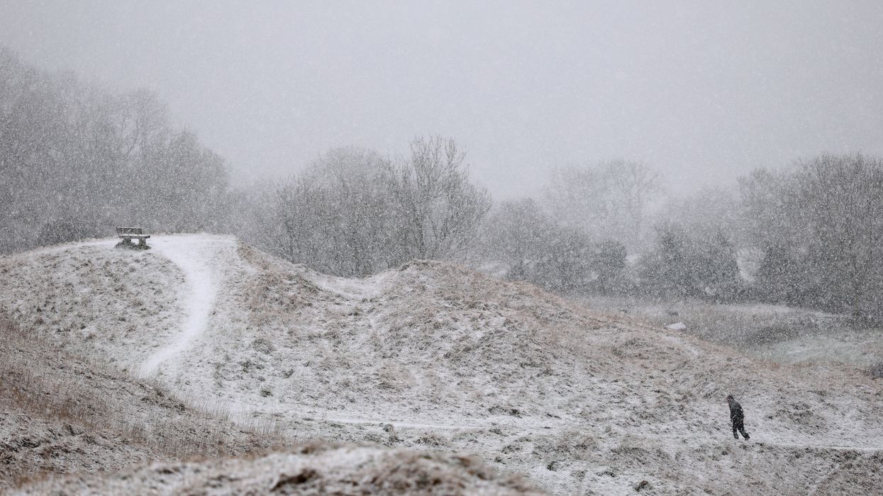
On Wednesday, snow showers were reported in parts of the Southern Uplands, Shropshire Hills, and the Cotswolds. Even racegoers attending day two of the Cheltenham Festival were met with a brief spell of snow, much to their surprise. The sudden cold has prompted the Met Office to issue a yellow warning for ice, affecting parts of northern England, particularly the Pennines and the Peak District. This warning extends into early Thursday, as icy conditions on roads and pavements pose potential hazards.
From spring warmth to Arctic chill
Just last weekend, the UK basked in unusually warm spring sunshine, with temperatures peaking at 19.7°C in Crosby, near Liverpool. Many areas enjoyed temperatures in the mid to high teens, which were 6 to 8 degrees above the March average and more typical of May weather. Sunday marked the warmest day of the year so far, giving a taste of the spring to come.
However, this warmth has been short-lived. As a colder weather pattern takes hold, temperatures have dropped by as much as 10 degrees in some areas, bringing a sharp chill to the air. Daytime highs for the remainder of this week are expected to range between 5 and 9°C, significantly below the average for mid-March, which typically sits around 7 to 11°C.
Overnight temperatures are forecast to dip close to or just below freezing for many parts of the country, with widespread frosts expected. The brisk north to north-easterly winds will also make it feel even colder than the thermometer suggests, adding to the wintry feel.
Snow and ice warnings are in place
The change in weather has been sudden and stark. Alongside the temperature drop, snow showers have appeared in several locations. While most of the UK will remain dry, there is a chance of further wintry flurries, particularly in parts of Scotland and north-east England. These snow showers are expected to be light and intermittent, but they add to the wintry atmosphere gripping the country.
The Met Office’s yellow warning for ice has been issued in response to the risk of freezing overnight conditions, particularly affecting northern England. The warning is in place over Wednesday night into Thursday morning, covering areas like the Pennines and the Peak District, where ice on roads and pavements could make for hazardous travel conditions.
Spring’s big temperature swings
Springtime in the UK is often characterised by big swings in temperature, and this March is proving no exception. As we approach the spring equinox on 20 March, the length of daylight is increasing, and the sun’s strength is growing. However, spring is also a time when wind direction can dramatically influence the weather.
At the beginning of March, southerly winds brought warm air up from the tropics, leading to the above-average temperatures we enjoyed during the weekend. But a shift in wind direction to a northerly flow has now brought much colder air down from the Arctic. These cold northerly winds are the reason for the sharp drop in temperature and the wintry conditions currently affecting much of the UK.
The influence of sudden stratospheric warming
While the cold weather this week is due to the change in wind direction, there has also been much discussion about a phenomenon known as ‘sudden stratospheric warming’ (SSW). This event occurs high in the atmosphere, around six miles above the Earth’s surface, where temperatures can suddenly rise by tens of degrees.
In recent days, an SSW event has been observed, with temperatures at this height warming from -75°C to -30°C. This sudden warming of the stratosphere can sometimes disrupt weather patterns closer to the Earth’s surface, leading to much colder weather in the UK. However, the impact of SSW events is not always straightforward, and cold weather does not always follow. Meteorologists are keeping a close watch on this event to see how it might affect weather patterns later in March.
Cold but dry with some sunshine
Despite the chilly conditions, the outlook for the rest of the week is for largely dry weather, with some spells of sunshine breaking through. However, the cold air will remain in place, and those venturing outdoors will certainly feel the Arctic chill. For those in Scotland and north-east England, there is also the continued chance of further wintry flurries.
As spring progresses, these big swings in temperature are likely to continue, reminding us that the weather at this time of year can be unpredictable. While the recent warmth may have been a glimpse of what’s to come, the current cold spell is a reminder that winter’s chill can still bite as we transition into the new season.


