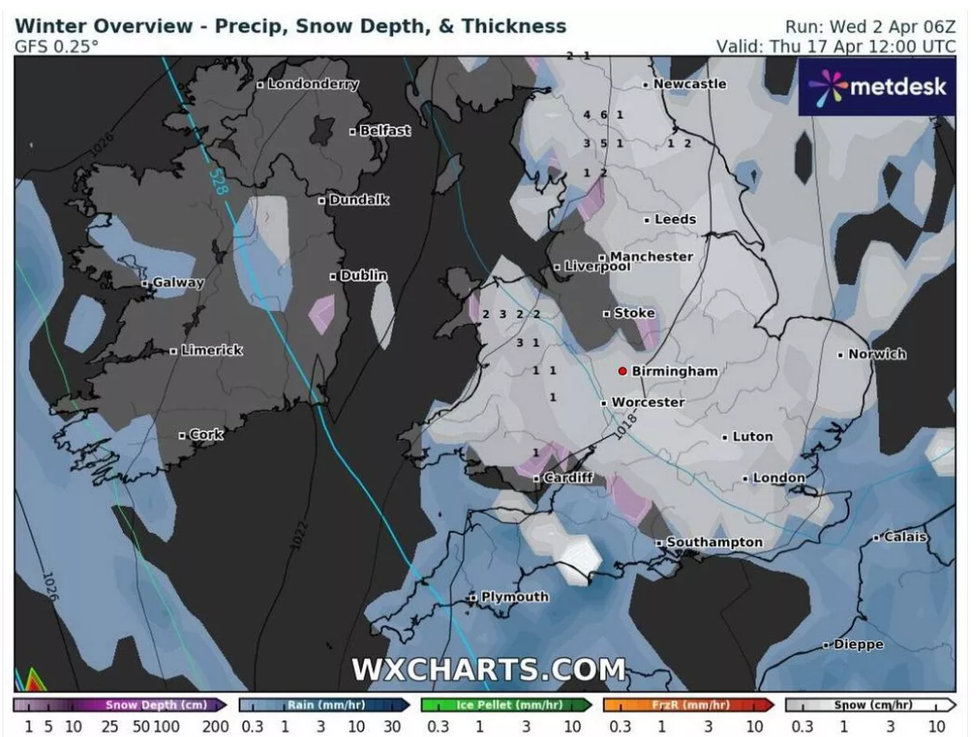
After enjoying the sunniest March on record, Britain is in for an unexpected turn in the weather this April, with forecasts pointing to a blast of wintry conditions. According to weather maps from WX Charts, snow could make a widespread return across England and Wales in mid-April, accompanied by a sharp dip in temperatures.
While spring is officially underway and warmer days have given a welcome taste of summer ahead, it seems the sunshine might soon be swapped for snowflakes in several regions. This sudden change could temporarily put a stop to the dry and sunny spell many have enjoyed so far this month.

WX Charts predicts that snow will begin falling over northern parts of England and Wales from Wednesday, 16 April. Areas such as Cumbria, Northumberland and County Durham are expected to be the first to feel the wintry bite. By the following day, Thursday 17 April, the snow is forecast to drift further south, potentially reaching parts of the Midlands and central England.
The North Pennines may experience heavy snowfall, with rates of up to 4cm per hour expected at the height of the downpour. Meanwhile, a light dusting could be seen further south from Birmingham to Stoke-on-Trent, extending across the West Midlands and Staffordshire.
By midday on Friday, 18 April, the snow is predicted to have spread across much of the country. Large areas of the Midlands, the North, the East and the South East of England, as well as parts of Wales, could find themselves blanketed in white. WX Charts suggests snowfall intensity might peak again, with up to 6cm per hour falling over elevated regions such as the North Pennines.
The wintry conditions are expected to persist into Friday evening. By 6pm, patches of snow may still be present across southern England, the Midlands, and parts of the North and East. Come Saturday morning, 19 April, the snow will likely be limited to the East and North East of England, with up to 5cm expected in some areas, including parts of North Yorkshire.
Alongside the snowfall, temperatures are set to plummet across the country. Higher regions are likely to see the lowest readings, with the North Pennines possibly facing a bitter -8°C, while Snowdonia could dip to -7°C. Even more central areas such as the Midlands might see the mercury fall to -2°C.
Despite these chilly forecasts, the overall outlook for the latter half of April remains relatively calm. In its long-range forecast covering 16 to 30 April, the Met Office has indicated that weather patterns will likely be slow-moving, with high pressure continuing to dominate for much of the period.
“There could be some interludes of rain or showers for a time around mid-April,” the Met Office notes, “but on the whole plenty of dry and fine weather is expected with high pressure looking to remain in charge for most of the time.”
The Met Office also stated that temperatures are expected to be around or slightly above average overall, with some parts of the country experiencing warm daytime conditions inland. However, chilly nights could still occur, especially under clear skies.
This unusual mix of spring warmth and sudden snow serves as a reminder that UK weather can be anything but predictable. While many will be looking forward to longer days and rising temperatures, a brief return to wintry conditions will require residents in affected areas to stay alert and prepared.
Motorists in particular should take caution, especially in northern and central areas, where snow and freezing temperatures could make travel conditions difficult. As always, keeping an eye on local forecasts will be key for anyone planning to travel mid-month.
Whether it’s sunglasses or snow shovels, it seems Britons might need both this April.


 Anjana Vasan
 Romesh Ranganathan


 Jasvir Singh CBE, MPs Deirdre Costigan, Catherine West, Sarah Coombes, Kanishka Narayan, councillor Sunny Brar and Vidhya Alakeson, deputy chief of staff at 10 Downing Street, at a Holi celebration last Monday (24)